
At J&E Tex Drones LLC, we deliver high-accuracy 2D and 3D drone mapping solutions designed for construction, surveying, inspections, and land development. Using the advanced DJI Matrice 4E paired with the Emlid RS2+ RTK GNSS receiver, we produce survey-grade data with exceptional clarity and centimeter-level precision.
Our professional drone mapping services in Central Texas include land mapping, aerial mapping, orthomosaic mapping, and 2D–3D mapping for large rural properties, ranches, and construction sites. These services support planning, documentation, and visualization needs using high-accuracy RTK-enabled drones.
Our mapping services include:
High-resolution 2D orthomosaic maps
Detailed 3D models and digital twins
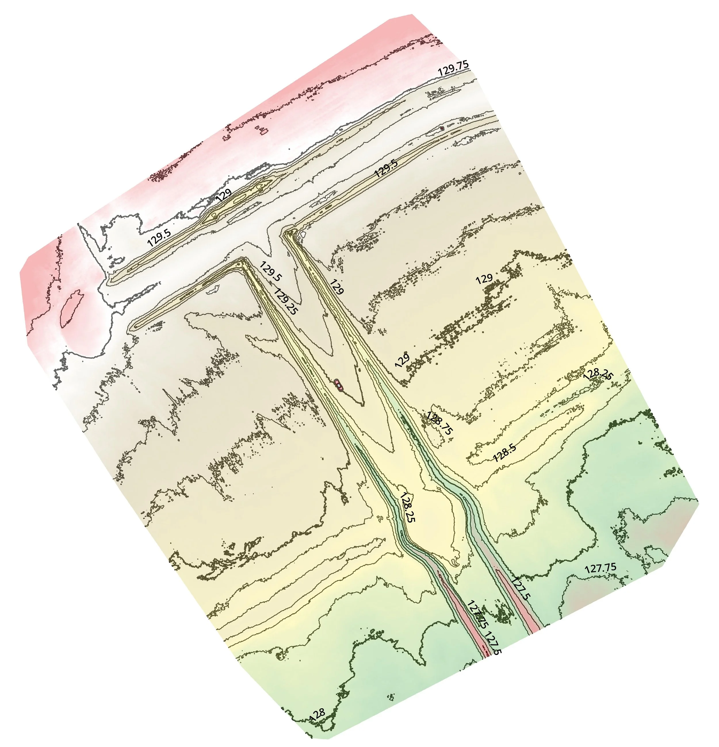
Flat maps with contour lines
Interactive 3D terrain and contour maps
With an outstanding Ground Sample Distance (GSD) of 0.50 to 0.37, our deliverables far exceed the industry standard of 1.5–2.5. This means sharper details, more accurate measurements, and more reliable results for planning, development, and documentation.
Whether you need elevation data, progress tracking, cut-fill insights, or complete site visualization, our powerful mapping workflow provides the accuracy and consistency your project demands.
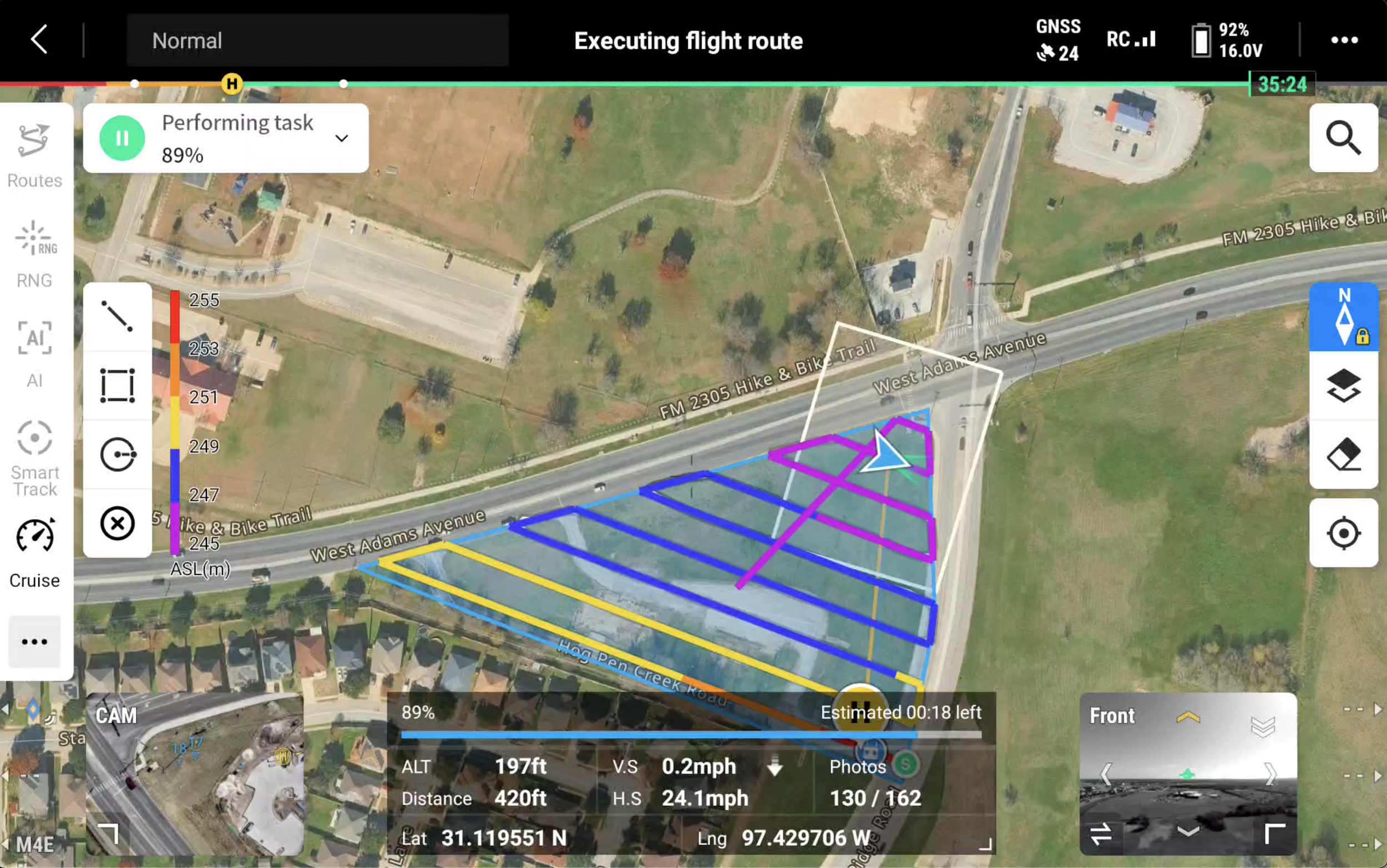
J&E Tex Drones LLC utilizes waypoints in construction projects to program precise flight paths, enabling automated aerial footage capture at specific locations. This ensures consistent progress tracking over time and provides a detailed visual record of the project's development—eliminating the need for manual piloting at each point, saving time, and ensuring accurate data collection across the site.
These photos were taken over an 8-month period. The project is still ongoing, and I will provide updates upon completion. You can rely on J&E Tex Drones LLC for your construction projects!
For unmatched 2D and 3D orthomosaic mapping, J&E Tex Drones LLC is the partner you can count on. With a strong commitment to precision, efficiency, and the latest drone technology, we deliver aerial mapping results you can trust. Here’s why we’re the right choice for your next project
2D Ortho Capture
3D Oblique Capture
Using the DJI Matrice 4E equipped with state-of-the-art technology and high-resolution cameras, we capture detailed, accurate imagery that ensures your orthomosaics are clear, precise, and ready for analysis.
With advanced drone technology and precision processing, we create flat maps, contour maps that bring your site to life. These powerful tools provide topographic insight, accurate elevation data, and dynamic visualization—perfect for construction, land development, and site planning.
J&E Tex Drones LLC, safety and compliance come first. We strictly follow FAA regulations, and our licensed pilots are trained to conduct every flight responsibly while maintaining the highest standards of professionalism.
When you choose J&E Tex Drones LLC, you gain a reliable partner for your 2D and 3D orthomosaic mapping needs. From agriculture to construction and beyond, our expertise and advanced technology ensure precise, efficient, and top-quality results.